Valles Marineris:

Remote Sensing


II. Remote Sensing
In an age where probes and people can't yet go to Mars to drill for themselves, the more that can be inferred from current data, the more focused future studies can be, thus maximizing scientific return. Data from Mars is collected in one of three ways: Earth-based observations, observations from Martian orbit and observations from the surface of Mars itself. The first method of observation unfortunately does not provide good imaging capabilities, and in fact is not able to detect Valles Marineris. The latter two however are, and can do so in amazing detail.
IIa. Probes
Image credit: National Space Science Data Center
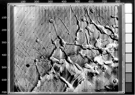
Figure 1: Image of Noctis Labyrinthus,
west most part of Valles Marineris, captured by Mariner 9
Credit: National�Space Science�Data�Center
The first probe to detect the Valles Marineris was Mariner 9, when it snapped photos of the feature in question in 1971 (Figure 1) as part of its normal mapping operations. As a tribute to its discoverer, this newly-found canyon system was called the Valles Marineris (Mariner Valley). Two Viking probes which followed took extensive photographs of this region and is the basis for many Mars studies today since these data sets are more mature than recent sets from current missions. The Viking I and II probes consisted of each an orbiter and a lander, and between them managed to image the entire planet. Of relevance to the Valles Marineris, the Viking I lander touched down on July 20, 1976 in Chryse Planitia, an outflow plain north-east of the canyon. The Mars Pathfinder mission in 1998 also touched down in Chryse Planitia, however since there was no orbiter component to the Pathfinder mission, the data obtained is very localized to its landing site.

There are two probes actively studying Mars: Mars Global Surveyor (MGS) and Mars Odyssey. Both of which have numerous instruments on board to help study Martian geology, and both of which target the Valles Marineris in the course of their normal operation. It is from these probes that the most detailed observations are made, however much of the information collected was only very recently, or still is, in peer review and not yet widely available for interpretation.
IIb. Instrumentation
Image credit: NASA’s Jet Propulsion Laboratory
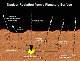
Figure 2: Diagram showing source energy and radiation
for the operation of a gamma-ray spectrometer in space
Credit: NASA�s Jet Propulsion Laboratory
Among these various probes were carried four main instruments of interest. The first is a Gamma Ray Spectrometer (GRS), which operates and obtains data similarly to spectrometers here on Earth, and resides on the Mars Odyssey craft. With this device, it is possible to measure the abundance and distribution of around 20 different elements, including silicon, oxygen, iron, magnesium, potassium, aluminum, calcium, sulfur and carbon. This device is also sensitive to chlorine, a key element that in significant amounts may suggest the presence of ancient lakebeds and/or oceans (University of Arizona, 2002). The GRS differs from spectrometers on Earth primarily in the energy source used to excite atoms in the sample being viewed. The feasibility of using an on-board power source prohibit the instrument from actively causing excitation, so instead it observes gamma rays omitted by the Martian surface in response to being struck by ambient cosmic rays, most of which originate from the Sun (Figure 2). The GRS was only fully deployed on June 4, 2002, so data returned is still rather preliminary.

Image credit: NASA/JPL/Arizona State University
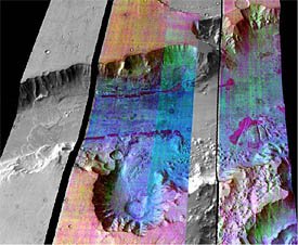
Figure 3: False colour infrared image from Mars Odyssey
draped over elevation data from Mars Global
Surveyor. Different colours represent different
minerals (e.g., dark purple represents olivine).
Credit: NASA/JPL/Arizona State University
The second instrument of interest is the Thermal Emission Imaging System (THEMIS), also aboard Mars Odyssey. This device primarily measures infrared (IR) light to detect mineral compositions (Figure 3). Infrared light is emitted by any object with a temperature greater than 0�K, allowing observations of temperature variances throughout day-night cycles. In addition, every mineral, gas and compound has a unique spectral signature (Arizona State University, 2001) that can be compared with known pure signatures on Earth.

The third instrument is the Mars Orbiter Laser Altimeter (MOLA) on-board MGS. Its purpose is to measure the precise altitude and topography of Mars by firing IR laser pulses at the Martian surface and measuring the amount of time passed for the reflected beam to be received by the MOLA.

The fourth set of instruments, and perhaps the most important, are the optical (visible light) cameras aboard every probe to Mars. These range in resolution capabilities from 1km per pixel for the Mariner 9 probe, 8m, 150m and 300m per pixel for the Viking Orbiters, 100m per pixel for THEMIS aboard Mars Odyssey, to 1m per pixel for the Mars Orbital Camera (MOC) on MGS (Arizona State University, 2002; Williams, D.R., 2001; Williams, D.R., 2002).